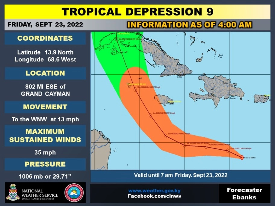
Tropical Depression 9 - Update - 23/9/2022
Tropical Depression 9 - Update - 23/9/2022
Convection this morning has increased primarily to the west of the area of low pressure we have been monitoring in the central Caribbean Sea, currently passing by to the north of Curacao island.
The system already possessed a well-defined circulation for the last 12 to 18 hours, but it was only overnight that the ongoing convective activity was able to persist long enough near the center to be considered a tropical cyclone.
The current motion right now is estimated to be off to the west-northwest at 290/12 kt. In the short-term, the depression is forecast to bend back more westward as a narrow east-to-west oriented mid-level ridge builds in behind the weakness left behind from Fiona.
The Cayman Islands National Weather Service will continue to monitor the progress of this Depression. The public is advised to keep abreast on the progress of Tropical Depression 9.
Latest News
-
Clean-up Underway at JGHS Following Lavatory OverflowEducation19 June 2025, 04:58 AM
-
PSPB Relocating to New Office in Cricket SquareGovernment19 June 2025, 04:57 AM
-
URCO (OfReg) Concerned Over Prolonged Disruption of Flow TV Services; Calls for Greater Local Resilience and AccountabilityUtilities19 June 2025, 04:56 AM
-
Premier Ebanks' First Official Europe TripGovernment19 June 2025, 04:52 AM
-
Anthony S. Eden Hospital Pharmacy to reopen on WednesdayHealth18 June 2025, 05:04 AM


